
Mapa topográfico Savannah
Mapa interactivo
Haga clic en el mapa para ver la altitud.
Acerca de este mapa
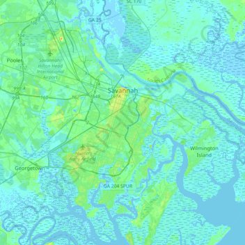
Nombre: Mapa topográfico Savannah, altitud, relieve.
Lugar: Savannah, Chatham County, Georgia, United States (31.88785 -81.37143 32.18966 -81.02952)
Altitud media: 4 m
Altitud mínima: -5 m
Altitud máxima: 33 m
Savannah is prone to flooding, due to abundant rainfall, an elevation at just above sea level, and the shape of the coastline, which poses a greater surge risk during hurricanes. The city currently uses five canals. In addition, several pumping stations have been built to help reduce the effects of flash flooding.
Otros mapas topográficos
Haga clic en un mapa para ver su topografía, su altitud y su relieve.
Oakdale
United States > Georgia > Chatham County > Savannah
Oakdale, Savannah, Chatham County, Georgia, 31406, United States
Altitud media: 10 m
Thunderbolt
United States > Georgia > Chatham County
Thunderbolt, Chatham County, Georgia, United States
Altitud media: 5 m
Welwood
United States > Georgia > Chatham County > Savannah
Welwood, Savannah, Chatham County, Georgia, 31409, United States
Altitud media: 7 m
Tybee Island
United States > Georgia > Chatham County
Tybee Island, Chatham County, Georgia, 31328, United States
Altitud media: 1 m
O'Leary
United States > Georgia > Chatham County > Port Wentworth > O'Leary
O'Leary, Port Wentworth, Chatham County, Georgia, 31407, United States
Altitud media: 5 m