
Mapa topográfico Hiawatha
Mapa interactivo
Haga clic en el mapa para ver la altitud.
Acerca de este mapa
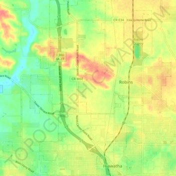
Nombre: Mapa topográfico Hiawatha, altitud, relieve.
Lugar: Hiawatha, Linn County, Iowa, 52233, United States (42.03467 -91.71640 42.10266 -91.66302)
Altitud media: 256 m
Altitud mínima: 226 m
Altitud máxima: 288 m
The elevation of Hiawatha is 850 feet (260 m) above sea level.[2]
Otros mapas topográficos
Haga clic en un mapa para ver su topografía, su altitud y su relieve.
Cedar Rapids
United States > Iowa > Linn County
Cedar Rapids, Linn County, Iowa, United States
Altitud media: 245 m
Bertram
United States > Iowa > Linn County
Bertram, Linn County, Iowa, United States
Altitud media: 232 m
Toddville
United States > Iowa > Linn County
Toddville, Linn County, Iowa, 52341, United States
Altitud media: 254 m
Marion
United States > Iowa > Linn County
Marion, Linn County, Iowa, 52302, United States
Altitud media: 256 m
Cedar Rapids
United States > Iowa > Linn County > Cedar Rapids
Cedar Rapids, Linn County, Iowa, 52401, United States
Altitud media: 249 m
Bertram
United States > Iowa > Linn County > Bertram > Bertram
Bertram, Linn County, Iowa, United States
Altitud media: 231 m
Central City
United States > Iowa > Linn County > Central City
Central City, Linn County, Iowa, 52214, United States
Altitud media: 269 m
Robins
United States > Iowa > Linn County > Robins
Robins, Linn County, Iowa, 52328, United States
Altitud media: 262 m
Palo
United States > Iowa > Linn County > Palo
Palo, Linn County, Iowa, United States
Altitud media: 229 m
Central City
United States > Iowa > Linn County
Central City, Linn County, Iowa, United States
Altitud media: 265 m
Springville
United States > Iowa > Linn County
Springville, Linn County, Iowa, 52336, United States
Altitud media: 265 m
Mount Vernon
United States > Iowa > Linn County > Mount Vernon
Mount Vernon, Linn County, Iowa, 52314, United States
Altitud media: 254 m