
Gracias por apoyar a este sitio ❤️
Haz una donación
Haz una donación
Mapa topográfico Modasa
Haga clic en el mapa para ver la altitud.
Gracias por apoyar a este sitio ❤️
Haz una donación
Haz una donación
Modasa
Se encuentra a una altitud de 142 m s. n. m. a 105 km de la capital estatal, Gandhinagar, en la zona horaria UTC +5:30.
Gracias por apoyar a este sitio ❤️
Haz una donación
Haz una donación
Acerca de este mapa
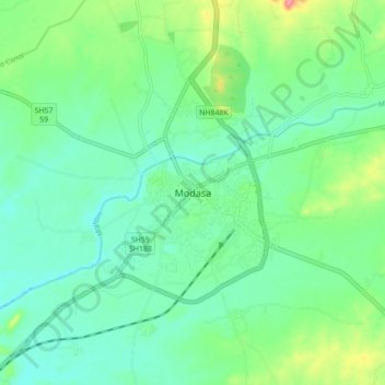
Nombre: Mapa topográfico Modasa, altitud, relieve.
Lugar: Modasa, Modasa Taluka, Aravalli, Guyarat, 383315, India (23.42342 73.25906 23.50342 73.33906)
Altitud media: 149 m
Altitud mínima: 125 m
Altitud máxima: 211 m
Gracias por apoyar a este sitio ❤️
Haz una donación
Haz una donación