
Mapa topográfico Villa La Angostura
Mapa interactivo
Haga clic en el mapa para ver la altitud.
Acerca de este mapa
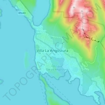
Nombre: Mapa topográfico Villa La Angostura, altitud, relieve.
Altitud media: 921 m
Altitud mínima: 755 m
Altitud máxima: 1.824 m
Otros mapas topográficos
Haga clic en un mapa para ver su topografía, su altitud y su relieve.
Volcán Lanín
El Lanín (en mapudungún, Pillañzegüñ) es un estratovolcán considerado activo, ubicado en el sur de Argentina y Chile. Tiene una altitud de 3776 metros sobre el nivel del mar, este volcán se encuentra incluido en el Cinturón de Fuego del Pacífico. Por primera vez en tiempos históricos se detectó…
Altitud media: 3.005 m