
Mapa topográfico Monte Fuji
Mapa interactivo
Haga clic en el mapa para ver la altitud.
Monte Fuji
El monte Fuji 富士山 (Fujisan, 富士山? pronunciación japonesa: [ ɸɯꜜdʑisaɴ ]), también conocido como Fujiyama por un error de transliteración, es el pico más alto de la isla de Honshu y de todo Japón, con 3776 metros de altitud. Se encuentra entre las prefecturas de Shizuoka y Yamanashi en el Japón central y justo al oeste de Tokio, desde donde se puede observar en un día despejado. El Fuji es un estratovolcán y es el símbolo de Japón.
Acerca de este mapa
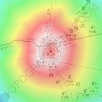
Nombre: Mapa topográfico Monte Fuji, altitud, relieve.
Altitud media: 3.261 m
Altitud mínima: 2.656 m
Altitud máxima: 3.757 m