
Mapa topográfico Parque Nacional Torres del Paine
Mapa interactivo
Haga clic en el mapa para ver la altitud.
Acerca de este mapa
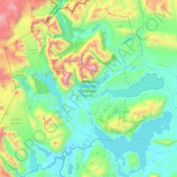
Nombre: Mapa topográfico Parque Nacional Torres del Paine, altitud, relieve.
Altitud media: 560 m
Altitud mínima: 7 m
Altitud máxima: 2.734 m
Otros mapas topográficos
Haga clic en un mapa para ver su topografía, su altitud y su relieve.
Puerto Natales
Chile > Región de Magallanes y de la Antártica Chilena > Provincia de Última Esperanza
Altitud media: 141 m
Puerto Williams
Chile > Región de Magallanes y de la Antártica Chilena > Provincia de la Antártica Chilena > Cabo de Hornos
La isla Navarino presenta un relieve de origen subglacial y más redondeado que el relieve abrupto y escarpado de la vecina isla Hoste, la otra gran isla de la zona sur del archipiélago. Las cumbres rara vez sobrepasan los 1000 m de altitud, siendo el picacho Dientes de Navarino la cumbre de mayor…
Altitud media: 151 m
Isla Santa Rosa
Chile > Región de Magallanes y de la Antártica Chilena > Provincia de Última Esperanza
Altitud media: 7 m
Volcán Aguilera
Chile > Región de Magallanes y de la Antártica Chilena > Provincia de Última Esperanza
Altitud media: 1.141 m
Cerro Castillo
Chile > Región de Magallanes y de la Antártica Chilena > Provincia de Última Esperanza > Torres del Paine
Altitud media: 155 m
Cerro Castillo
Chile > Región de Magallanes y de la Antártica Chilena > Provincia de Última Esperanza > Torres del Paine
Altitud media: 155 m
Cabo de Hornos
Chile > Región de Magallanes y de la Antártica Chilena > Provincia de la Antártica Chilena > Cabo de Hornos
Altitud media: 49 m
Puerto Edén
Chile > Región de Magallanes y de la Antártica Chilena > Provincia de Última Esperanza
Altitud media: 35 m
Cerro Castillo
Chile > Región de Magallanes y de la Antártica Chilena > Provincia de Última Esperanza > Torres del Paine
Altitud media: 155 m
Monte Fitz Roy
Chile > Región de Magallanes y de la Antártica Chilena > Provincia de Última Esperanza > Natales
A pesar de tener una altitud promedio (no llega a la mitad de la de los gigantes de los Andes) la montaña tiene la reputación de ser de "dificultad extrema": presenta enormes extensiones de lajas casi verticales, pulidas y resbaladizas sobre las que baten constantemente vientos de enorme fuerza, requiriendo…
Altitud media: 2.023 m
Zona Austral
Chile > Región de Magallanes y de la Antártica Chilena > Provincia de Última Esperanza
Altitud media: 768 m
Puerto Natales
Chile > Región de Magallanes y de la Antártica Chilena > Provincia de Última Esperanza
Altitud media: 141 m
Torres del Paine
Chile > Región de Magallanes y de la Antártica Chilena > Provincia de Última Esperanza
Altitud media: 1.596 m
Huertos Familiares
Chile > Región de Magallanes y de la Antártica Chilena > Provincia de Última Esperanza > Natales
Altitud media: 73 m
Villa Dorotea
Chile > Región de Magallanes y de la Antártica Chilena > Provincia de Última Esperanza > Natales
Altitud media: 487 m
Punta Delgada
Chile > Región de Magallanes y de la Antártica Chilena > Provincia de Magallanes > San Gregorio
Altitud media: 2 m
Monte Verde
Chile > Región de Magallanes y de la Antártica Chilena > Provincia de Magallanes > Punta Arenas
Altitud media: 102 m
Isla Salamandra
Chile > Región de Magallanes y de la Antártica Chilena > Provincia de Última Esperanza > Natales
Altitud media: 3 m
Mirador Nordenskjöld
Chile > Región de Magallanes y de la Antártica Chilena > Provincia de Última Esperanza > Torres del Paine
Altitud media: 108 m
Zona Austral
Chile > Región de Magallanes y de la Antártica Chilena > Provincia de Última Esperanza > Natales
Altitud media: 768 m
Puerto Williams
Chile > Región de Magallanes y de la Antártica Chilena > Provincia de la Antártica Chilena > Cabo de Hornos
La isla Navarino presenta un relieve de origen subglacial y más redondeado que el relieve abrupto y escarpado de la vecina isla Hoste, la otra gran isla de la zona sur del archipiélago. Las cumbres rara vez sobrepasan los 1000 m de altitud, siendo el picacho Dientes de Navarino la cumbre de mayor…
Altitud media: 151 m
Monte Fenton
Chile > Región de Magallanes y de la Antártica Chilena > Provincia de Magallanes > Punta Arenas
Altitud media: 486 m
Reserva Nacional Laguna Parrillar
Chile > Región de Magallanes y de la Antártica Chilena > Punta Arenas
Altitud media: 448 m
Mirador Cuernos
Chile > Región de Magallanes y de la Antártica Chilena > Provincia de Última Esperanza > Torres del Paine
Altitud media: 269 m
Lago Riesco
Chile > Región de Magallanes y de la Antártica Chilena > Provincia de Magallanes > Río Verde
Altitud media: 280 m
Pueblo Vasco
Chile > Región de Magallanes y de la Antártica Chilena > Punta Arenas > Pampa Alegre > Pueblo Vasco
Altitud media: 42 m
Golfo Sarmiento de Gamboa
Chile > Región de Magallanes y de la Antártica Chilena > Natales
Altitud media: 0 m
Cabo de Hornos
Chile > Región de Magallanes y de la Antártica Chilena > Provincia de la Antártica Chilena > Cabo de Hornos
Altitud media: 49 m
Cordillera Riesco
Chile > Región de Magallanes y de la Antártica Chilena > Río Verde
Altitud media: 543 m
Volcán Lautaro
Chile > Región de Magallanes y de la Antártica Chilena > Provincia de Última Esperanza > Natales
Altitud media: 3.028 m