
Mapa topográfico Chihuahua
Mapa interactivo
Haga clic en el mapa para ver la altitud.
Chihuahua
La ciudad de Chihuahua se encuentra enclavada en un valle rodeada de las pequeñas serranías que recorren el municipio en dirección norte-sur, al oeste las serranías de Huerachi, Majalca, La Campana, El Nido, El Pajarito y la Sierra azul, al este Nombre de Dios, El Cobre, La Parrita y Ojo Laguna, por el suroeste las serranías de La Silla, El Charco, Mápula, y El Cerro grande. Al noreste de la ciudad se ubica el valle Tabalaopa-Aldama, bordeado por las sierras de Nombre de Dios al occidente, Peña Blanca y la Gloria al oriente. Su elevación varia en sentido este-oeste, en el aeropuerto Roberto Fierro es de 1348 m s. n. m., en el centro de la ciudad es de 1420 m s. n. m. y al oeste y norte alcanza los 1550 m s. n. m. sus principales elevaciones son el Cerro Grande con 1900 m s. n. m. y el Cerro Coronel 1650 m s. n. m. en el sur de la ciudad.
Acerca de este mapa
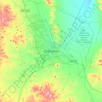
Nombre: Mapa topográfico Chihuahua, altitud, relieve.
Altitud media: 1.555 m
Altitud mínima: 1.295 m
Altitud máxima: 2.245 m
Otros mapas topográficos
Haga clic en un mapa para ver su topografía, su altitud y su relieve.