
Mapa topográfico Linares
Mapa interactivo
Haga clic en el mapa para ver la altitud.
Linares
Al embalse de Colbún S.A. se accede por un camino de tierra y ripio que parte de la vía asfaltada que va desde Linares al pueblo de Colbún. Así, se puede llegar inclusive hasta el túnel Canal Melado, pasando por la zona de Embalse Ancoa y Roblería, en un recorrido de aproximadamente 55 km. El embalse, cuya superficie es de 417 hectáreas, y con una altitud que oscila entre los 1.300 y 2010 metros sobre el nivel del mar, se encuentra en la precordillera de la provincia de Linares.
Acerca de este mapa
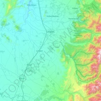
Nombre: Mapa topográfico Linares, altitud, relieve.
Lugar: Linares, Provincia de Linares, Región del Maule, Chile (-36.22591 -71.79710 -35.70333 -71.00628)
Altitud media: 377 m
Altitud mínima: 74 m
Altitud máxima: 2.440 m
Otros mapas topográficos
Haga clic en un mapa para ver su topografía, su altitud y su relieve.
Termas de Quinamávida
Chile > Región del Maule > Provincia de Linares > Colbún > Paso Rari
Altitud media: 214 m
San Ignacio
Chile > Región del Maule > Provincia de Linares > Yerbas Buenas > Villa El Esfuerzo
Altitud media: 197 m
Huerta del Maule
Chile > Región del Maule > Provincia de Linares > San Javier
El suelo es de topografía montañosa, con cierto grado de erosión de manto. El clima de la zona es templado húmedo, con una temperatura promedio de 14.4 °C y una precipitación media anual de 680 mm, que se concentra entre los meses de junio y agosto.
Altitud media: 314 m
Embalse Ancoa
Chile > Región del Maule > Provincia de Linares > Linares > Embalse Ancoa
Altitud media: 587 m
Peñuelas
Chile > Región del Maule > Provincia de Linares > Yerbas Buenas > Peñuelas
Altitud media: 176 m
Santa Ana de Queri
Chile > Región del Maule > Provincia de Linares > Yerbas Buenas > Santa Ana de Queri
Altitud media: 243 m
Parque Oratorio Virgen del Carmen
Chile > Región del Maule > Provincia de Linares > Linares
Altitud media: 158 m
Callejón El Manzanal
Chile > Región del Maule > Provincia de Linares > Yerbas Buenas > Semillero > Callejón El Manzanal
Altitud media: 240 m
Bajos de Huenutil
Chile > Región del Maule > Provincia de Linares > Parral > Bajos de Huenutil
Altitud media: 196 m
Vega de Salas
Chile > Región del Maule > Provincia de Linares > Linares > Vega de Salas
Altitud media: 466 m
Pamparraza
Chile > Región del Maule > Provincia de Linares > Linares > Pamparraza
Altitud media: 155 m