
Gracias por apoyar a este sitio ❤️
Haz una donación
Haz una donación
Mapa topográfico Western Ghats
Haga clic en el mapa para ver la altitud.
Gracias por apoyar a este sitio ❤️
Haz una donación
Haz una donación
Western Ghats
La elevación media está alrededor de los 900 metros. También son conocidas como las montañas Sahyadri en Maharashtra y al norte de Karnataka y la región de Malabar en Kerala. Fue declarado Patrimonio de la Humanidad por la Unesco en 2012.
Gracias por apoyar a este sitio ❤️
Haz una donación
Haz una donación
Acerca de este mapa
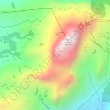
Nombre: Mapa topográfico Western Ghats, altitud, relieve.
Lugar: Western Ghats, Devikulam, Idukki, Kerala, 685614, India (10.16595 77.05795 10.16605 77.05805)
Altitud media: 2.225 m
Altitud mínima: 1.828 m
Altitud máxima: 2.685 m
Gracias por apoyar a este sitio ❤️
Haz una donación
Haz una donación